
Expand Cachuma Resource Conservation District Capacity
The Cachuma Resource Conservation District (CRCD) plays a critical role in our community as a partner to and bridge between farmers, ranchers and other landowners and conservation groups and agencies focused on the health of our land, water, soil, wildlife, agriculture and food systems.

Fire Fuel Management at Arroyo Hondo Preserve
In June of 2021, the Land Trust of Santa Barbara received a grant of $23,588 from the Coastal Conservancy for a targeted prescribed grazing project at the Arroyo Hondo Preserve, a project that the RPP team had identified through their outreach efforts to the Land Trust and helped facilitate funding for.
Unified Fire Prevention Project Tracking Website
Santa Barbara County Fire Department (SBCFD) serves as Santa Barbara County's Cal Fire Unit and regularly produces an Annual Strategic Unit Plan as mandated by Cal Fire that inventories the fire prevention projects SBCFD has in various stages of its planning and implementation processes.

Santa Barbara Mountain Communities Defensible Space Plan
The Los Padres National Forest (LPNF) undertook a planning effort to identify, prioritize and plan a series of fire prevention and mitigation activities to reduce the risk of wildfire to mountain communities including West Camino Cielo, Painted Cave and Rosario Park.

Regional Lompoc Valley Community Wildfire Protection Plan (CWPP)
The Lompoc region has been identified as a high priority for fire prevention activities by the modeling completed by the RPP team but the region lacks a Community Wildfire Protection Plan (CWPP).

Addressing WUI Wildfire Buffer Gaps
The communities throughout Santa Barbara County have varying degrees of wildfire buffer along their WUI edges. Goleta benefits from significant portions of its WUI edged by irrigated orchards …

Dangermond Preserve Fire Resilience Projects
The Nature Conservancy stewards the 24,000-acre Jack and Laura Dangermond Preserve (JLDP) at Point Conception. JLDP is of biological and cultural significance regionally and globally.

San Antonio Creek Community Defensible Space Project
In June 2021, the Santa Barbara County Fire Department received funding from the State Coastal Conservancy to implement a community defensible space project in the San Antonio Creek area foothills…

Carpinteria Summerland Fire Hazard Fuels Reduction Treatment Project
In June 2021, the Carpinteria Summerland Fire Protection District received funding from the State Coastal Conservancy to conduct a multi-pronged fuels reduction treatment program…

Reintegrating Indigenous Burning Practices
Prescribed fire can help reduce fuel loads in key areas that are safe to burn and where there has been a dearth of fire in the past. Prescribed fire is used as a tool to promote ecological health and reduce fire risk…

Assessment of Jurisdictional Wildland Firefighting Liability: Assessment and Education for Electeds
This is an educational tool that LAFCO needs to weigh the cost of wildfire suppression when considering a SOI, or more importantly, an annexation that involves any land with inherent fire severity.

Countywide Fine Resolution LIDAR Data
There is a long term need to acquire Santa Barbara County wide, cross jurisdictional, LIDAR data in addition to the periodic orthographic overflights that are undertaken for aerial mosaic mapping product needs.

Campsite Fire Buffers on Paradise Road and Other Recreational Areas Throughout the County
Paradise Road and other public land recreation areas throughout the County are highly visited community resources utilized by all income levels. These areas often include fire pits, grills and picnic areas where…

Tepusquet Vegetation Management Project
Tepusquet Canyon includes underserved communities and low income migrant workers, making this a high priority area from an equity perspective.

Coordination of WUI Projects Across Management Entity Boundaries for example with LPNF, VSFB, Land Trusts, and County Parks
When fires occur, they often start in areas of the national forest and enter into the unincorporated WUI portions of the County. There is a need to conduct detailed mapping of invasive, flammable vegetation or other fire risks…

Inventory of Needed Riparian Restoration
The efforts that were conducted in Goleta should be replicated throughout different portions of Santa Barbara County, as staffing and capacity allows.
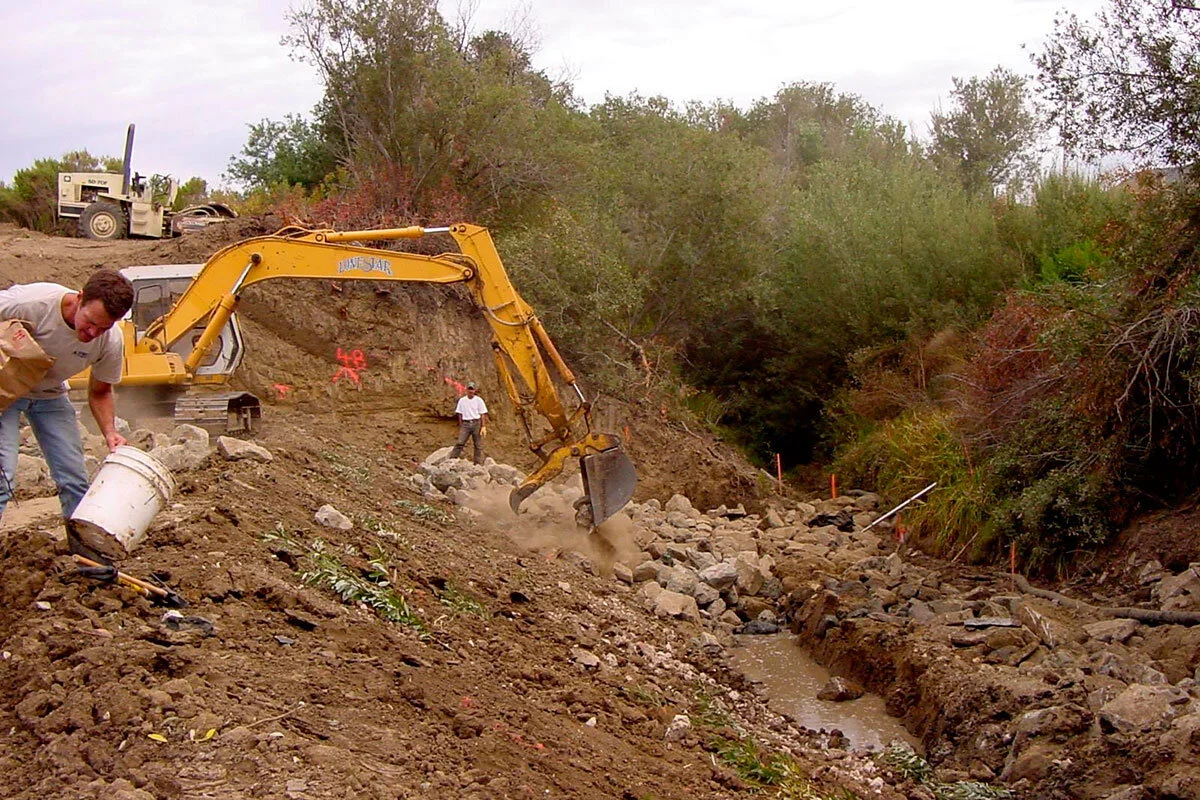
Restoration with a Fire Resilience Focus: Riparian Restoration in Goleta Valley to Reduce Fire Risk
Healthy riparian corridors with natural unimpaired hydrology are natural fire breaks, with well watered vegetation acting to catch and extinguish embers and dampen fire advancement.

Prescribed Grazing: Develop a Countywide Plan
Prescribed grazing (also known as prescribed herbivory) enables fuel treatment in sloped and difficult to access areas where other vegetation management options are challenging or impractical.